May Hill
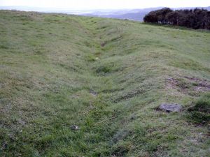
May Hill is the most familiar landmark for many miles around, with its near circular mound and the crowning clump of trees, and at 275 metres (969 feet) it is the highest point around. On a clear day you can see up to 12 other counties. May Hill has a circular trench (right), 100 metres in diameter, and is said to be an old earthwork from the Iron Age. Within this area is a mound that is said to be a round barrow.
The hill was enclosed by an act of parliament in 1873 and passed into the care of the National Trust in 1935.
All in a Name
It was said that it came from the Admiral May, who had trees planted on the summit as a visual aid for ships navigating the River Severn. There is, however, no mention of Admiral May. It has been noted that there was once an Anglo-Saxon tribe called Magesoetan who lived on or around May Hill and that the syllable mag evolved to become may [1] .
In Samuel Rudder's New History of Gloucestershire published in 1779 he refers to the hill as Yartleton Hill but notes that the association of May Hill comes from the hill's involvement with the May Day games [2,3] .
The Trees
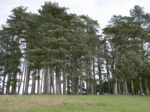
The trees atop May Hill probably date back to ancient times when most of the Forest of Dean was woodland. They have been recorded several times throughout history as a noteworthy landmark.
A local story says that Prince Rupert and some of his Cavaliers took shelter from the trees for a short time during the siege of Gloucester in 1643. It is known that Crockett's Hole (see below) was used as a place of shelter during the English civil war.
It was believed that the planting of the trees took place to commemorate the golden jubilee of Queen Victoria in 1887. However, a clergyman writing 60 years prior to this event undermines the theory when he writes: "May Hill, a conspicuous round-topped hill distinguished by a plantation on the summit". A painting from 1780, around the same time as the clergyman, also shows a clump of trees present on the summit. A map of Gloucestershire published by the Ordnance Survey in 1883 also shows the trees present.
May Hill was often used as a beacon to ships navigating the River Severn and, consequently, the trees were used for these beacons. Over time, the dwindling number of trees meant that the hill was beginning to lose its iconic identity. Eventually, money was raised to fund new trees to accompany those that remained to commemorate the golden jubilee in 1887. A plaque was erected to record this event.
It has been said that from some angles the trees look like a ploughman and his team. John Masefield describes it in his poem "The Everlasting Mercy".
Whilst still under the name of Yartleton Hill, the neighbouring parishes met on the hill to decide who should have the rights to the land - as after all it was common land. Another old custom was that groups of young people from the district of Newent would gather on top of the hill on May Day (the beginning of summer according to the Celtic calender) and pretend to have a battle. One side would fight for winter to stay, whilst the other would fight for summer and the final score was always Summer 5, Winter 0. Afterwards everyone would all retire to Newent carrying flowers and green branches [4] .
Buried Treasure
Gloucestershire has several references to hidden treasure in underground chambers. Naturally, May Hill is one of these such places. One chamber is said to exist on the east side of the hill, near Yartleton Wood. Several people have tried to find it without much success, one of these was a disbanded soldier named Fairfax, who travelled all the way from London in 1665 to explore the hole. He didn't find anything. Crockett's Hole, it is called, is mentioned in Chancellor Parsons' notes on the diocese of Gloucester from about 1700. He says that the hole is supposedly full of riches and was a place of safety in times of persecution under Queen Mary [5] .
A cavern in a field belonging to Great Cugley Farm, two miles due east from the summit of May Hill has been recorded several times throughout history. The most detailed description of the cavern was written by the engineer Stephen Ballard in 1834: "It is not known when this [cavern] was cut or for what purpose. It extends under the earth a great way... There is plenty of room just within the entrance, a sort of apartment 10 or 12 feet wide out of which a small passage leads... I have no doubt it is an artificial passage for the tool marks are now plainly to be seen". Fifty years after Ballard's discovery, some horses caused the roof of the cavern to collapse, although the passageway at the back of the cavern remained intact [1] .
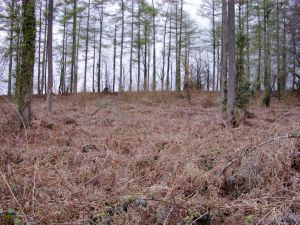
In Easter 2005 we went in search of the cavern and the entrance to the tunnel on top of May Hill and at Great Cugley Farm. The picture on the left shows that the woods on top of May Hill are overgrown and covered with bracken. Hence, finding the tunnel entrance would be extremely difficult. The cavern at Great Cugley Farm looked more promising when we found a hole in the ground surrounded by trees. On closer inspection it is probably just the exit of an underground stream only present in Winter months, as the shape of the land suggests it had been cut by a stream. All that now remains of the cavern is a small depression in the ground next to a telegraph pole.
References
- Fletcher, C., "Ottakar's Local History Series: Gloucestershire", Tempus, 2001.
- Rudder, S., "A New History of Gloucestershire", Printed by Samuel Rudder, Cirencester, 1779.
- Rudge, T., "The History of the County of Gloucestershire brough down to the year 1803", Volume 2, printed for the author by G. F. Harris, Herald Newspaper Office, 1803.
- T. A. Ryder, "A Portrait of Gloucestershire", Robert Hale, London, 1976.
- Fendley, J., "Chancellor Parsons' Notes on the Diocese of Gloucester c. 1700" TBGAS, GRS 19.